
Identifikation
Titel
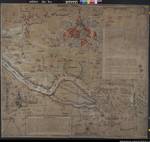
Karte der Elbe im Gebiet zwischen Hamburg und Lüneburg (mit Überschwemmungsgebieten, Deichen sowie Stadtansichten und Wappenzeichnungen)
Laufzeit
1569
Alte Archivsignatur
I C a 1
Provenienz
(Teil-)Provenienz
Übersichtskarten
Informationen / Notizen
Zusatzinformationen
vgl. auch NLA HA Kartensammlung Nr. 30/9 m
Ergänzungen
Klassifikation Teil B
elbe
Herstellerangaben
Urheber
Zeichner: Franz Buch; Martin Bokol
Weitere Angaben (Bild)
Format
122,5 x 135 cm
Blattzahl
1
Maßstab
ca. 1:35.000 - 1:40.000
| Aktion | Typ | Bezeichnung | Zugang | Info |
|---|---|---|---|---|
| Detailseite | Original | Karte | 0099 / 6 |
|
| Detailseite | Masterdigitalisat | Multimedia |
|
|
| Detailseite | Nutzungsdigitalisat | Multimedia |
|
 Digitalisate öffnen