
Identifikation
Titel
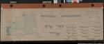
"Situations- und Nivellementsplan von dem Else-Fluss und der Umflut vor der Mühle zu Melle". östlich der Straße von Melle zum Bahnof. Blatt- und Pazellenzahlen der Gemarkungskarte. Vergl. Nr. 5
Ausf.-Art: Farbige Zeichnung
Herst.: Winter
Format: 40 x 128 cm
Maßstab: 1 : 80 bzw. 2000
Laufzeit
- 1877
Alte Archivsignatur
Rep 200 Nr. 2425
Provenienz
Organisations- und Aktenzeichen
B 17
Ergänzungen
Klassifikation Teil B
melle
Index-Gruppe
GEOB
Melle, Else-Fluss, Umflut, Mühle
PERS
Winter
| Aktion | Typ | Bezeichnung | Zugang | Info |
|---|---|---|---|---|
| Detailseite | Nutzungsdigitalisat | K |

|
|
| Detailseite | Masterdigitalisat | K |
|
|
| Detailseite | Original | Karte | 0300 / 1 |
|
 Digitalisate öffnen