
Identifikation
Titel
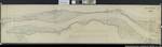
Karte der Elbe von Pölitz bis zur Elde
(Gebiet von Pölitz bei Gorleben bis zur Mündung der Löcknitz zwischen Gaarz und Dömitz)
(Kopie)
Maßstab : 1:5.000
Format: 48 x 196,5 cm
Zeichner: G. Schroeter
Band
Nebenlaufzeit von
1844
Provenienz
Organisations- und Aktenzeichen
acc. 359
(Teil-)Provenienz
Karten Dannenberg
Ergänzungen
Klassifikation Teil B
elbe
| Aktion | Typ | Bezeichnung | Zugang | Info |
|---|---|---|---|---|
| Detailseite | Original | Karte | 0099 / 4 |
|
| Detailseite | Masterdigitalisat | Multimedia |
|
|
| Detailseite | Nutzungsdigitalisat | Multimedia |
|
 Digitalisate öffnen