
Identifikation
Titel
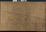
Übersicht über die Bombenschäden im Stadtgebiet Celle zwischen Klein-Hehlener-Straße und dem Mondhagen
(Plan of the damages by bombs in the town of Celle between Kl. Hehlenerstraße and Mondhagen)
Laufzeit
ca. 1945-1946
Alte Archivsignatur
Nds. 120 Lüneburg Acc. 1/83 Nr. 102
Provenienz
(Teil-)Provenienz
Karten Celle
Ergänzungen
Klassifikation Teil B
celle
Weitere Angaben (Bild)
Format
104 x 159 cm
Blattzahl
1
Maßstab
1:2.000
| Aktion | Typ | Bezeichnung | Zugang | Info |
|---|---|---|---|---|
| Detailseite | Original | Karte | 0099 / 6 |
|
| Detailseite | Masterdigitalisat | Multimedia |
|
|
| Detailseite | Nutzungsdigitalisat | Multimedia |
|
 Digitalisate öffnen