
Identification
Title
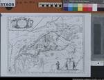
Topographische Karte der Grafschaften Bentheim und Steinfurt, ca. 1635/40
"Les comtez de Benthem u. Steinfurt" (kurze Beschreibung, frz.)
Life span
1635
User instructions
Blatt 25 eines Atlas-Werks. Das Original ist am 11.9.1986 an das Stadtarchiv Lingen zurückgegeben worden. Eine Reproduktion mit dem Negativ lagert unter der alten Signatur in der Kartenabteilung
Former identifier
Acc. 37/75 (Nachlass Beiß)
Additions
Classification PartB
bentheim
Further information (picture)
Format
37 x 50 cm
Design
Fotokopie
Number of sheets
1
Scale
1 : 500 - 170000
Index group
Index Place
Bentheim, Grafschaft
Steinfurt, Grafschaft
| Action | Type | Name | Access | Info |
|---|---|---|---|---|
| Detail page | Masterdigitalisat | Karte | 0300 / 1 |

|
| Detail page | Original | Karte | 0300 / 1 |
|
| Detail page | Nutzungsdigitalisat | Karte | 0300 / 1 |
|
 Show digital copies